
Klamath Falls

Home / Locations / Oregon / Klamath Falls
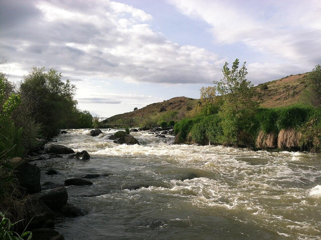
White water running downstream of Link River, Klamath Falls

Today’s Forecast:

88°F
Current Temperature
Clear
Station: KLMT
Observed at: 8:00 pm
Wind: 7 mph | Humidity: 9%
⚠️
Red Flag Warning
Red Flag Warning issued July 23 at 11:38AM PDT until July 25 at 9:00PM PDT by NWS Medford OR (Expires: July 25, 2026 11:00 pm)
Show Alert Details & Instructions
Description: The National Weather Service in Medford has issued a Red Flag Warning, which is in effect from 1 PM Friday to 9 PM PDT Saturday. The Fire Weather Watch is no longer in effect. * AFFECTED AREA...In northern California in Fire Weather Zones 284 and 285, including the Klamath, Shasta and Modoc National Forests. In Oregon, nearly all areas east of the Cascades, including the Klamath Basin, Fremont-Winema National Forest and the south central Oregon Desert including BLM land in Fire Weather Zones 624 and 625. * WINDS...Southwest to west 10 to 20 mph with gusts up to 45 mph both Friday and Saturday afternoon and evening. * MINIMUM HUMIDITY...5 to 15 percent. * DURATION...3 to 8 hours Friday and Saturday afternoon and evening. * DETAILED URL...View the hazard area in detail at https://weather.gov/wrh/hazards?wfo=mfr * ADDITIONAL DETAILS...The fire weather threat will decrease overnight with increasing humidities and lighter winds. Instructions: Follow all fire restrictions. You can find your county's emergency sign up form as well as links to fire restrictions at weather.gov/medford/wildfire. One less spark, one less wildfire. Be sure you're signed up for your county's emergency alert system. Familiarize yourself with your emergency plan and make sure you listen to emergency services. Visit ready.gov/plan for more information. A Red Flag Warning is issued when we identify weather conditions that promote rapid spread of fire which may become life- threatening. This does not mean there is a fire. These conditions are either occurring now or will begin soon. It is important to have multiple ways to receive information from authorities.

This Afternoon:Sunny, with a high near 91. West southwest wind around 8 mph.
Tonight:Clear. Low around 55, with temperatures rising to around 57 overnight. Northwest wind 1 to 7 mph.
Friday:Sunny, with a high near 93. South wind 1 to 16 mph, with gusts as high as 24 mph.

Today’s Report:

🛶 Paddling

Use Caution
  42 /100

Use Caution for paddling. High near 92°F. Breezy winds (16 mph).

  • Temp: Marginal weather factor
  • Rain: Favorable conditions
  • Wind: Marginal weather factor
  • Thunderstorm: Favorable conditions
Tomorrow's Outlook:
Use Caution 45/100

🚲 Biking

  12 /100

Not Recommended for biking. High near 92°F. Breezy winds (16 mph). Temperatures outside comfort limits (92°F).

  • Temp: Unfavorable weather factor
  • Rain: Favorable conditions
  • Wind: Marginal weather factor
  • Thunderstorm: Favorable conditions
Tomorrow's Outlook:
Use Caution 46/100

🎪 Outdoor Events / Activities

  12 /100

Not Recommended for outdoor events / activities. High near 92°F. Breezy winds (16 mph). Temperatures outside comfort limits (92°F).

  • Temp: Unfavorable weather factor
  • Rain: Favorable conditions
  • Wind: Marginal weather factor
  • Thunderstorm: Favorable conditions
Tomorrow's Outlook:
Use Caution 47/100

🐟 Fishing

Use Caution
  43 /100

Use Caution for fishing. High near 92°F. Breezy winds (16 mph).

  • Temp: Marginal weather factor
  • Rain: Favorable conditions
  • Wind: Marginal weather factor
  • Thunderstorm: Favorable conditions
Tomorrow's Outlook:
Use Caution 45/100

❄️ Snowmobiling

  5 /100

Not Recommended for snowmobiling. High near 92°F. Breezy winds (16 mph). Extreme heat (high near 92°F). Temperatures outside comfort limits (92°F).

  • Temp: Unfavorable weather factor
  • Rain: Favorable conditions
  • Wind: Marginal weather factor
  • Heat: Unfavorable weather factor
  • Thunderstorm: Favorable conditions
Tomorrow's Outlook:
Not Recommended 5/100

About Klamath Falls

Klamath Falls is a Klamath Basin planning page for lake and river paths, birding areas, paddling windows, bike routes, outdoor events, and gateway trips toward Crater Lake or Lava Beds country.

Make the Most of a Klamath Falls Day

Use wind, lake conditions, smoke, heat, and cold mornings to choose between paddling, biking, wildlife-area stops, or town-based outdoor plans.

Weather Tips for Klamath Falls

  • Lake wind, cold water, smoke, high-desert sun, cold nights, dust, thunderstorms, and winter ice can all affect Klamath Falls plans.
  • Check wind, cold water, current, river or lake levels, and lightning risk before choosing open water, river, or shoreline plans.
  • For biking, watch wind, wet pavement, muddy trails, smoke, heat, and road visibility.
  • Have a land-based backup ready when wind, waves, high flow, or storms make water plans less comfortable.

Nearby Towns and Areas

This page is meant to cover a roughly 25-mile outdoor-planning area around Klamath Falls, including Klamath Falls, Upper Klamath Lake, Link River and Moore Park areas, nearby refuges, Keno, and Klamath Basin travel routes. It can also be useful when planning outdoor time near:

  • Upper Klamath Lake
  • Moore Park
  • Link River Trail
  • Keno
  • Tulelake approaches
  • Running Y Ranch
  • Klamath Basin refuges
  • Lake Ewauna

Plan Around the Conditions

Use the forecast to choose the best version of Klamath Falls rather than forcing one itinerary. Match rain, wind, tides, river or lake conditions, trail surfaces, smoke, road access, seasonal closures, and temperature swings to the activity that gives your group the most comfortable day.

7-Day Forecast for Klamath Falls, OR

88°F
Current Temperature
Clear
Station: KLMT
Observed at: 8:00 pm
Wind: 7 mph | Humidity: 9%
Thu
91° 55°
0%
Fri
93° 53°
0%
Sat
86° 51°
0%
Sun
86° 51°
0%
Mon
86° 52°
0%
Tue
87° 53°
0%
Wed
91° 54°
0%

7-Day High Temperature Trend

91° Thu 93° Fri 86° Sat 86° Sun 86° Mon 87° Tue 91° Wed

7-Day Low Temperature Trend

55° Thu 53° Fri 51° Sat 51° Sun 52° Mon 53° Tue 54° Wed

📊 7-Day Outdoor Outlook

Good Fair Poor 20 Thu 20 Fri 20 Sat 20 Sun 20 Mon 20 Tue 20 Wed
Forecast data from the National Weather Service  |  Last Updated: July 23, 2026 8:23 pm CDT